
Groundwater Resources in Muthanna Governorate, South of Iraq
Article Sidebar
Main Article Content


Abstract
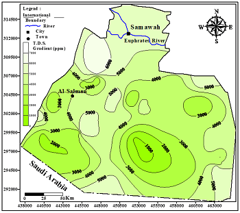
Muthanna Governorate, located in southern Iraq, is the second-largest governorate in the country by area. The unconfined aquifer was studied by identifying the geological formations that form this aquifer. This research aims to use stratigraphic succession to establish geological correlations and identify formations that serve as groundwater aquifers. It also aims to identify and isolate the geological formations comprising the unconfined aquifer, as well as to assess its hydrogeological characteristics and groundwater hydrochemical properties. Geological maps of Muthanna Governorate and data from deep wells as well as fifty-nine drilled wells in the study area were used to prepare a series of geological sections. These sections provide valuable insights into the areas of each geological formation that contribute to the unconfined aquifer. Five main zones were identified, where the unconfined aquifer was sometimes considered an isolated geological formation (e.g., the Umm Er-Radhuma or Dammam formations) and sometimes consisted of a succession of two formations (e.g., the Euphrates and Dammam formations, or the Dammam and Umm Er-Radhuma formations). The results showed that the average hydraulic parameters—namely, thickness, total depth, transmissivity, and water table—were 68.7 meters, 151.5 meters, 133 m²/day, and 162.6 meters above sea level, respectively. The groundwater salinity distribution map indicated several locations with high salinity values, which are attributed to the different lithologies forming the aquifer as well as the varied environmental depositional conditions of the geological formations that compose it. Additionally, the groundwater moves continuously from recharge areas toward discharge areas in three directions. Two primary salinity types were identified: calcium sulphate and sodium sulphate. The salinity, reflected by cation and anion concentrations, caused groundwater contamination in some areas of Muthanna's unconfined aquifer due to increasing concentrations. Consequently, five groundwater samples were suitable for human consumption, nine were appropriate for agricultural use, and forty-nine were suitable for animal use.
Article Details

This work is licensed under a Creative Commons Attribution-NonCommercial 4.0 International License.
References
- Harter T. Basic concepts of groundwater hydrology. UCANR Publications, 2003.
- Domenico PA, Schwartz FW. Physical and chemical hydrogeology. John wiley & sons, 1997.
- Appelo CAJ, Postma D. Geochemistry, Groundwater and Pollution. (Appelo CAJ, Postma D, eds.). CRC Press, 2004. https://doi.org/10.1201/9781439833544
- United Nation Assistance Mission for Iraq - IAU - The inter - agency information and analysis unit. Muthanna Governorate Profile. UNAMI. 2010,3.
- Maaroof B F. Geographical Assessment of Natural Resources at Abu–Hadair Drainage Basin in Al-Salman Desert, Southern Iraq. Indian Journal of Ecology. 2021, 48(3): 797-802.
- Al-Sudani HIZ. Groundwater system of Dibdibba sandstone aquifer in south of Iraq. Applied Water Science. 2019, 9(4). https://doi.org/10.1007/s13201-019-0952-6
- Al-Jiburi AK, Al-Basrawi NH. Hydrogeology. Iraqi Bulletin Geological Mining. Special Issue. 2009: 77-91.
- Al-Aajibi MJ, Al-Jiashi JW. Optimal Use of Natural Resources in Al-Muthanna Desert (Soil as A model). IOP Conference Series: Earth and Environmental Science. 2021, 923(1): 012078. https://doi.org/10.1088/1755-1315/923/1/012078
- Abed F, Al-Khafaji S, Hasan M. Social Responsibility According to Imam Al-Juwaini in his Book “Ghiyath al-Umam Fi Al-Thiath Al-Zulm”: A Fundamental Study. Dirasat: Human and Social Sciences. 2022, 49(3). https://doi.org/10.35516/hum.v49i3.1357
- Al-Sheikh ON, AL-Shamma’a AM. Hydrochemical of Groundwater for Al Dammam unconfined Aquifer within Al-Salman Basin, Al-Muthana Governorate, South West Iraq. Iraqi Journal of Science. Published online June 26, 2019: 1336-1349. https://doi.org/10.24996/ijs.2019.60.6.17
- Al-Sudani HIZ. Rainfall Returns Periods in Iraq. Journal of University of Babylon for Engineering Sciences. 2019, 27(2): 1-9. https://doi.org/10.29196/jubes.v27i2.2288
- Al-Dabbas MA, Al-Ameri YK, Kadhim WH. Groundwater Quality Investigation of the Dammam Unconfined Aquifer, Umaid Area – Muthanna Governorate - Iraq. Advances In Natural And Applied Sciences. Published online 2018. https://doi.org/10.22587/anas.2018.12.5.5
- Al-Sudani HIZ, Jawad SB, Naom FH, Bashoo DY, Ali BM. Hydrogeology of aquifers in the western Desert—West and South of Euphrates River. National Program of best use of water resources in Euphrates Basin. Axis IV, Ministry of Irrigation, Baghdad, Iraq. 2001: 100.
- Al-Shamaa AM. Hydrogological and tectonic investigation of the southern part of the Western Desert (Qasra-Shbicha area). Ph.D. Thesis, College of science, Baghdad University, Iraq, (in Arabic). 1993: 200.
- Hassan KM, Yacoub SY, Abdul Amir E. The Geology of Al-Salman Quadrangle Sheet NH-38-6 (GM 36) Scale 1:250 000. Technical Report No. 2404. Directorate of Geological Survey. State Establishment of Geological Survey and Mining (GEOSURV). Baghdad. Iraq. 1995: 21.
- Deikran DB. The Geology of Suq- Al-Shyukh Quadrangle Sheet NI-38-10 (GM 37) Scale 1:250 000. Technical Report No. 2402. Directorate of Geological Survey. State Establishment of Geological Survey and Mining (GEOSURV). Baghdad. Iraq. 1995: 28.
- Deikran DB. The Geology of Ansab Quadrangle Sheet NH-38-10 (GM 40) Scale 1:250 000. Technical Report No. 2323. Directorate of Geological Survey. State Establishment of Geological Survey and Mining (GEOSURV). Baghdad. Iraq. 1994: 17.
- Deikran DB. The Geology of Ar-Rukhaimiy and Kuwait Quadrangle Sheet NH-38-11 and Sheet NH-38-12 (GM 41 and GM 42) Scale 1:250 000. Technical Report No. 2321. Directorate of Geological Survey. State Establishment of Geological Survey and Mining (GEOSURV). Baghdad. Iraq. 1995: 22.
- General Commission of Groundwater. Geological and Hydrogeological information of Groundwater wells in Muthanna Governorate. internal reports. Ministry of Water Resources. Baghdad. Iraq, 2024.
- Al-Sudani HIZ. Influence of structural factors on Groundwater System-West of Iraq. Basrah journal of Science. 2018, 36(1): 1-15.
- Al-Sudani H. Hydraulic Parameters of Groundwater Aquifers in Khan-Al-Baghdadi Area. Engineering and Technology Journal. 2018, 36(2B): 136-146. https://doi.org/10.30684/etj.36.2b.8
- Robinson M, Ward R. Hydrology: Principles and Processes. Water Intelligence Online. 2017, 16: 9781780407296. https://doi.org/10.2166/9781780407296
- Collins A. Geochemistry of Oil Field Water, Development in Petroleum Science. Elesvier. Amestrdam, Holand. 1975: 496.
- Al-Sudani HIZ. Groundwater Utilization and Water Quality in Khanaqin District, Diyala Governorate, Northeast of Iraq. Resources Environment and Information Engineering. 2025, 6(1): 305-312. https://doi.org/10.25082/reie.2024.01.004
- Al-Sudani HIZ. Assessment of Groundwater Resources and Hydro-Geochemical Characteristics of Mandali Basin - East Iraq. Resources Environment and Information Engineering. 2025, 6(1): 295-304. https://doi.org/10.25082/reie.2024.01.003
- Fetter CW. Applied hydrogeology, 4th ed. Prentice-Hall, Upper Saddle River. 2000: 598.
- Selvakumar S, Ramkumar K, Chandrasekar N, et al. Groundwater quality and its suitability for drinking and irrigational use in the Southern Tiruchirappalli district, Tamil Nadu, India. Applied Water Science. 2014, 7(1): 411-420. https://doi.org/10.1007/s13201-014-0256-9
- Al-Sudani HIZ. Hydrogeological study of Khan Al-Baghdadi area in Anbar governorate - West of Iraq. Diyala Journal for Pure Science. 2017, 13(2): 192-207. https://doi.org/10.24237/djps.1302.240a
- Boyd CE. Water Quality. Springer US, 2000. https://doi.org/10.1007/978-1-4615-4485-2
- Al-Sudani HIZ. Hydrogeological and hydrochemical study of groundwater aquifer in Wasit Governorate, Eastern Iraq. Resources Environment and Information Engineering. 2024, 6(1): 270-279. https://doi.org/10.25082/reie.2024.01.001
- Al-Sudani HIZ. Hydrogeological Conditions and Groundwater Geochemistry of Badra - Zurbatia Area in Wasit Governorate - East of Iraq. International Journal of Recent Engineering Science. 2025, 12(3): 1-9. https://doi.org/10.14445/23497157/ijres-v12i3p101
- World health organization (WHO). Guidelines for drinking water quality. Fourth edition, 5, Geneva. 2011: 541.
- IQS DWS. 417 (2001) Central Organization for Quality Control and Standardization. Council of Ministers, Republic of Iraq.
- Ayers RS, Westcot DW. Water quality for agriculture. Rome: Food and agriculture organization of the United Nations, 1985.
