
Vol 6 No 1 (2024)

Vol 6 No 1 (2024)
Published: 2024-12-09
Research Article
Pages 354-380
 S. K. Egereonu, U. U. Egereonu, J. C. Ike, A. I. Otuonye, O. C. Nwokonkwo, U. L. Onu, C. Onwuka, C. Enyia, A. O. Emeagubor
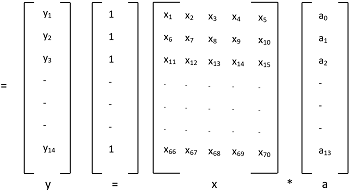
Geographic Information System (GIS) and Matrix Laboratory (MATLAB) Models were used to study air quality in parts of Imo State. Primary data were obtained by conducting relevant analysis using standard instrumental methods on open-air rainwater samples collected in the dry and the rainy seasons for two consecutive years. GIS showed that the pollutants were present throughout the year. Artificial Neural Network (ANN) of MATLAB 2015 was used to represent data with regards to pollutant concentration in all the areas considered. Analysis of Variance (ANOVA) and the Multi-Comparative plots showed that all the Criteria pollutants except CO were affected by seasonal change. All the pollutants exceeded the WHO, NAAQS and FEPA Standards with the Air Quality Index (AQI) indicating poor air quality with grade E for all the areas studied. Hot spot locations appeared more for SO2, PM10, in the dry seasons while the average concentration of CO showed the same trend with NO2with higher levels during the rainy seasons. Therefore, the findings from this research provides knowledge of patterns and trends of air pollutant dispersion and other reliable information that could be useful to the Government, relevant pollution regulatory agencies and the general public for better proactive decision making and pollution control in Imo State.
Pages 340-353
Groundwater Resources in Muthanna Governorate, South of Iraq
Hussein Ilaibi Zamil Al-Sudani
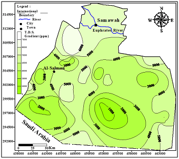
Muthanna Governorate, located in southern Iraq, is the second-largest governorate in the country by area. The unconfined aquifer was studied by identifying the geological formations that form this aquifer. This research aims to use stratigraphic succession to establish geological correlations and identify formations that serve as groundwater aquifers. It also aims to identify and isolate the geological formations comprising the unconfined aquifer, as well as to assess its hydrogeological characteristics and groundwater hydrochemical properties. Geological maps of Muthanna Governorate and data from deep wells as well as fifty-nine drilled wells in the study area were used to prepare a series of geological sections. These sections provide valuable insights into the areas of each geological formation that contribute to the unconfined aquifer. Five main zones were identified, where the unconfined aquifer was sometimes considered an isolated geological formation (e.g., the Umm Er-Radhuma or Dammam formations) and sometimes consisted of a succession of two formations (e.g., the Euphrates and Dammam formations, or the Dammam and Umm Er-Radhuma formations). The results showed that the average hydraulic parameters—namely, thickness, total depth, transmissivity, and water table—were 68.7 meters, 151.5 meters, 133 m²/day, and 162.6 meters above sea level, respectively. The groundwater salinity distribution map indicated several locations with high salinity values, which are attributed to the different lithologies forming the aquifer as well as the varied environmental depositional conditions of the geological formations that compose it. Additionally, the groundwater moves continuously from recharge areas toward discharge areas in three directions. Two primary salinity types were identified: calcium sulphate and sodium sulphate. The salinity, reflected by cation and anion concentrations, caused groundwater contamination in some areas of Muthanna's unconfined aquifer due to increasing concentrations. Consequently, five groundwater samples were suitable for human consumption, nine were appropriate for agricultural use, and forty-nine were suitable for animal use.

Pages 321-339
Victor C. Eze, Ugochukwu U. Egereonu, Nkechinyere J. Okoro, Chinenye H. Emele, Chiedozie C. Aralu, Beatrice L. Aka, Chinonye C. Ijioma, Maryclaret N. Nwaodu, Favour A. Echenu, Sunny K. Egereonu, Andaline O. Emeagubor
This study analytically assesses the water quality of the Omambala and Ezu Rivers, both of which are subject to significant anthropogenic influences and surface runoff, resulting in pronounced pollution. The primary objective was to assess the water quality using the Water Quality Index (WQI) methodology, focusing on both physicochemical parameters and toxic elements. A total of thirty water samples were collected, fifteen from each river, at three strategically selected sampling locations. Physicochemical analyses were conducted following the American Public Health Association (APHA) standard methods, and the findings were evaluated against the permissible limits established by the World Health Organization (WHO) and the Nigerian Standard for Drinking Water Quality (NSDWQ). Results revealed that both rivers are heavily polluted, with WQI values indicating severe degradation: 568.269 for River Omambala and 672.99 for River Ezu, the latter demonstrating a higher level of pollution. Conversely, the assessment of potentially toxic elements yielded WQI values of 423.67 for River Omambala and 289.93 for River Ezu, suggesting greater contamination in River Omambala regarding these elements. Notably, parameters such as pH, temperature, dissolved oxygen, total dissolved solids, total hardness, chlorides, and sulfates fell below NSDWQ permissible limits, while electrical conductivity, biochemical oxygen demand, turbidity, and nitrates exceeded recommended thresholds for both rivers. Elevated concentrations of Arsenic and Iron were observed, posing additional health risks. These findings underscore the critical influence of anthropogenic activities on water quality. Comprehensive management strategies, including pollution mitigation measures and community engagement, are urgently recommended to restore the ecological integrity of these rivers. Further research is warranted to explore the long-term impacts of observed pollution and the effectiveness of implemented interventions.

Pages 313-320
Hussein Ilaibi Zamil Al-Sudani
Groundwater is vital for domestic and agricultural purposes, particularly in rapidly urbanizing regions worldwide. The area between Badra and Zurbatia, which is located in Wasit Governorate, in the eastern side of Iraq, was investigated during the fieldwork in 2024. The area is important in terms of agriculture and poultry, and livestock husbandry. This research aims to evaluate the groundwater resources in the study area. The research will focus on evaluating and determining the hydrogeological and hyro-geochemical of the confined aquifer, which has been exploited largely in the last decade. (30) Wells were inventoried during the field study and used to demonstrate the hydrogeological conditions and geochemistry of the groundwater aquifer. The results showed that the confined aquifer consists of quaternary deposits and pebbly sandstone layers. The mean thickness, water permeability (transmissivity), and maximum yields of the aquifer were 46 meters, 112 square meters/day, and 655 cubic meters/day of maximum yields, respectively. The distribution map of groundwater salinity demonstrates a regular decrease in concentrations towards the southern part of the area due to groundwater recharge from infiltrated surface water to the unconfined aquifer, according to the hydraulic connection between the confined and the unconfined aquifers. The origin of groundwater is continental, with brackish to saline types. The calcium sulphate is recorded as the main dominant type of groundwater. The utilization of groundwater was mainly for animal purposes.
Pages 305-312
Hussein Ilaibi Zamil Al-Sudani
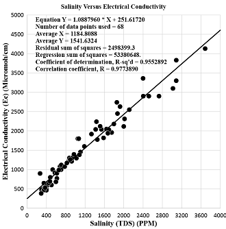
Groundwater is often considered the main source of freshwater in many places worldwide. Due to their importance and susceptibility to depletion and contamination, efficient management of groundwater resources is needed. Groundwater quality depends on many factors, including geology, source water quality, and land use type. The present study dealt with the hydrochemistry of groundwater resources in the Khanaqin district, which is located in Diyala Governorate in the northeast of Iraq. The exposed geological formations in Khanaqin district range in age from Upper Jurassic up to Recent. Quaternary deposits, Bai Hassan and Injana formations were the two main types of groundwater aquifers, unconfined and confined. 68 well samples were used in hydrochemical analysis. The groundwater sampling included both aquifers in the area. The physicochemical parameters showed that the groundwater of aquifers is moderately brackish to saline. A strong linear relationship between the salinity (TDS) and electrical conductivity (EC) was obtained in the studied area. The correlation coefficient (R) was 97.73%. The salinity distribution showed a large area in the northeastern and southwestern parts of the studied area where the salinity decreased below 1000 PPM. The central and eastern parts of the studied area showed a significant increase in salinity concentration. Two polluted locations were located in the area of study with salinity concentration over 2000 PPM. The origin of groundwater was continental with a moderate brackish to saline type. 53% of the two major types of groundwater were determined in the studied area, calcium sulphate and calcium bicarbonate, with 18 samples for each one. The utilization of groundwater in the area indicates that thirty-six samples of groundwater could be used for human purposes, while fifty-eight and sixty-eight samples were utilized to be used for agriculture and animal purposes, respectively.
