
Aims and Scope
![]() Resources Environment and Information Engineering (REIE) (eISSN: 2661-3131) is an open access, continuously published, international, refereed journal which mainly studies the interdisciplinary and comprehensive fields of geospatial information science, resource science and environmental science. REIE publishes high quality special report, investigations, techniques and methods, original research work, etc.
Resources Environment and Information Engineering (REIE) (eISSN: 2661-3131) is an open access, continuously published, international, refereed journal which mainly studies the interdisciplinary and comprehensive fields of geospatial information science, resource science and environmental science. REIE publishes high quality special report, investigations, techniques and methods, original research work, etc.
REIE will accept high-profile submissions including but not limited to:
• Environmental engineering
• Environmental Science
• Environmental monitoring and evaluation
• Improvement of ecological environment and pollution control
• Water pollution control theory and technology
• Air pollution control and catalytic technology
• Environmental planning and management
• Surveying and Mapping Engineering
• Geographic information system
• Remote sensing science and technology
Current Issue

Vol 8 No 1 (2026)
Published: 2026-01-11
Research Article
Pages 464-477
 Vincent Gwengwe, Ephraim Vunain
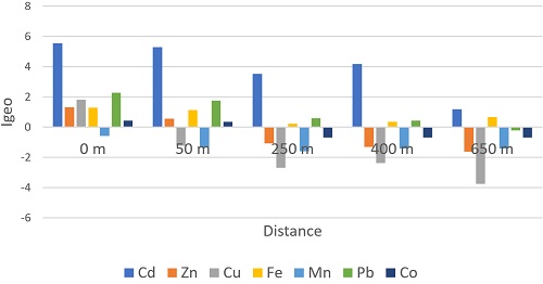
Uncontrolled disposal of municipal solid waste is a growing environmental concern in developing countries, contributing to heavy metal accumulation in surrounding soils and water. This study assessed the concentrations, spatial distribution, and ecological risks of heavy metals around the Mzedi municipal dumpsite in Blantyre, Malawi. Composite soil samples were collected at 0 m, 50 m, 250 m, 400 m, and 650 m from the dumpsite, while surface water samples were taken from a nearby stream receiving runoff. Samples were analyzed for cadmium (Cd), zinc (Zn), copper (Cu), iron (Fe), manganese (Mn), lead (Pb), and cobalt (Co) using atomic absorption spectrophotometry. Contamination and risk levels were evaluated using the Contamination Factor (CF), Geo-accumulation Index (Igeo), Enrichment Factor (EF), and Potential Ecological Risk Index (PERI). Soil metal concentrations decreased with distance from the dumpsite in the order Fe > Mn > Zn > Cu > Pb > Cd > Co. Cadmium exhibited the highest contamination levels, with CF (70.00), Igeo (5.54), and EF (19.17) at 0 m indicating extremely polluted conditions and severe anthropogenic enrichment. PERI values ranged from 2,181 at 0 m to 117 at 650 m, shifting from very high to low ecological risk. Cadmium contributed > 96% of the total ecological risk, confirming it as the dominant contributor to ecological risk. In surface water, Cd (0.006–0.008 mg/L) and Pb (0.025–0.030 mg/L) exceeded WHO drinking water guidelines, confirming leachate-driven contamination of the adjacent stream. While crop metal concentrations were not directly measured, the elevated soil cadmium levels indicate potential for plant uptake and possible human exposure. However, without direct crop analysis, we cannot confirm the extent of food chain transfer, quantify dietary exposure, or assess compliance with food safety standards. This highlights the critical need for targeted crop monitoring studies to validate the inferred human health risks. This study provides the first comprehensive quantitative assessment of ecological risk at the Mzedi dumpsite using multiple contamination indices and robust statistical analysis. The findings support precautionary management measures, including restrictions on farming directly on the dumpsite, upgrading of waste disposal infrastructure, and community awareness programs.
Pages 450-463
Erland G. Kolomyts
The well-known conceptual provisions on the ecological resources of forest cover as their ability to additionally absorb greenhouse gases through the mechanisms of carbon cycle regulation under global climate change are empirically substantiated. A predictive landscape-ecological analysis of forest cover in the Volga River basin is presented, which highlights the task of greenhouse gas sequestration included in the list of tasks of the Paris Agreement (2015) on climate change. Data from large-scale landscape surveys previously conducted by the author in the Middle and Upper Volga regions were used. Calculations of the carbon balance of forest formations in the Volga River basin were performed for global moderate and extreme warming scenarios. Multiple regression methods were used to reveal the spatial variability of forest carbon balance in relation to changes in forest ecosystems' adaptive potential and the climate predicted for 2100 by the global HadCM3 model, which was consistent with the current unprecedented rate of global warming. The absorption potential of indigenous and derivative boreal and nemoral forests was established; their ability to mitigate the effects of climate change, including the reduction of anthropogenic warming, was assessed. Contrasting changes in the ecological resources of boreal and nemoral forests amid global warming were identified. A quantitative assessment of the loss of ecological resources of forests in the Volga River basin since the beginning of intensive forest and land utilization was conducted. Using the Volga River basin as an example, a regional experiment was conducted to numerically solve the dual problem set by the Paris (2015) Agreement on Climate Change: namely, to calculate the sequestration of CO2 from the atmosphere by forest communities under current global warming, taking into account their adaptation to climate change.

Pages 442-449
Mahesh Borate, Prashant D. Deshmukh, Arunkumar Shetty
Atmospheric Air Pollution & Global Warming due to the emission of flue gases in the atmosphere is a major issue that is being faced by the world at present. This is due to the incomplete combustion of fuel, producing unwanted components in the flue gases, which are affecting our environment as well as nature badly day by day. It is extremely important to control pollution as well as global warming to preserve nature. This research paper has tried to discuss the cause of the exit of hot flue gases to the atmosphere and recovery of the same by controlling the exit of hot flue gases to the atmosphere. This can be controlled by the complete combustion of fuel as well as by converting the heat into energy. The equipment is installed on the furnace to recover heat losses as well as complete combustion. Ideally, industrial furnace efficiency is considered to be 30 percent for design calculations, which indicates that almost 70 percent of energy is being wasted. The combustion system is designed to achieve the required temperature with better temperature uniformity inside the combustion chamber. Automation by Auto ignition and Auto temperature control system is done for the safety and quality of the final product derived from the system. Hence, it is necessary to enhance the furnace efficiency for energy saving. This will also contribute to pollution control and global warming. An industrial furnace has a major role in the Iron and Steel Industry, Power generation, Ferrous and non-ferrous metals and alloys melting, Heat Treatment, and many more applications that consume maximum energy production globally. Hence, the energy-saving focus is required in this category. Energy-saving will not only enhance efficiency but also contribute to controlling pollution and global warming, too. Optimizing the furnace design by a robust design concept can help the end user achieve complete combustion. This will preserve nature for the next generation.
| ISSN: 2661-3131 Abbreviation: Resour Environ Inf Eng Editor-in-Chief: Prof. Yuesuo Yang(China) Publishing Frequency: Continuous publication Article Processing Charges (APC): Click here for more details Publishing Model: Open Access |

